Showing posts with label Space Exploration Electronics. Show all posts

Monday, June 30, 2014

The Mars Report - June 30th, 2014

              Welcome back My Dear Readers to The Other Shoe. I’d like to welcome you to an all new edition of ‘The Mars Report’. Thankfully, when I checked with the NASA/JPL web site today there were several new images from Curiosity. This is welcome news to be and means that you, My Dear Readers, have some great new images, from the Martian surface, to enjoy!

.

To be honest, this is a kind of special edition in that we have i9mages from two different Martian rovers, today. There will be two images from Curiosity, and there will be two images from Opportunity. That’s right; Opportunity is still working hard and producing great images and science. However, Spirit has fallen out of service. Remember, it was Spirit and Opportunity that were lunched, nearly simultaneously, the last time NASA/JPL sent rover(s). IT was their hope that two rovers, of a smaller design, could bring more differing imaging and science experiments.

.

Earlier, this year, I published an overview of the lives of both Spirit and Opportunity. There I discussed the ‘passing’ of the Martian rover Spirit during the last Martian Winter. NASA/JPL was unable to ‘park’ Spirit in a “shielded” environment prior to the onset of the harsh Martian Winter. Spirit was unable to charge its batteries and fell prey to the harsh conditions at are a Martian Winter. Now, on with today’s offerings from Curiosity and Opportunity.

.

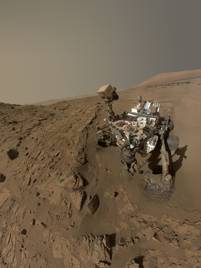
Our first image of the day is a ‘Self-Portrait’ of Curiosity! The image, below, is a composite of dozens of images taken by the Mars Hand Lens Imager (MAHLI),of the Curiosity rover during the months of April and May, 2014. The images were taken at the ‘Windjana’ sandstone rock site at ‘The Kimberly’ waypoint. The image does not include the end of the ‘rover arm’ in the image, because the MAHLI sits on the very end of that rover arm.

.

((Image thanks to NSA/JPL Curiosity team and the NASA/JPL web site)[1]

[caption id="attachment_3153" align="aligncenter" width="768"]Self-Portrait of/by Curiosity at ‘The Kimberly’ 4/2014 Self-Portrait of/by Curiosity at ‘The Kimberly’ 4/2014[/caption]

(Self-Portrait of/by Curiosity at ‘The Kimberly’ 4/2014)


.

Our next image, staying with the Curiosity rover, is of the sandstone rock sample take from Windjana. The rock sample has been named ‘Winnipesaukee’ by the scientists at NASA/JPL. Now, My Dear Readers, there are two images that make up of next offering. The image on the top half is of the rock sample ‘Winnipesaukee’. This image is a composite of two images; the first is a high definition ‘Black and White’ taken by the rover’s ChemCam remote micro-imager. This image was then combined with a Color image that was taken with the telephoto-lens camera of Curiosity's Mast Camera (Mastcam). The result is a strikingly deep and colorful image. Now, the bottom half of this offering is of the Spectrograph taken by the 3-D laser imaging system on the ChemCam of the rover. Each of the ten different colors, represented in the image above, correlates to the spectrograph bar in the image below. This gives us an accurate representation of the different minerals/chemicals found in this one rock sample.

.

(Image thanks to NSA/JPL Curiosity team and the NASA/JPL web site) [2]

[caption id="attachment_3152" align="aligncenter" width="630"]Martian Rock and Dust Filling Studied with Laser and Camera Martian Rock and Dust Filling Studied with Laser and Camera[/caption]

(Martian Rock and Dust Filling Studied with Laser and Camera)


.

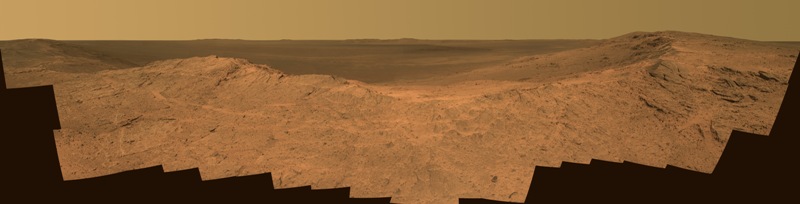
That, My Dear Readers, will being us to the two final images of this week’s edition of ‘The Mars Report’. Yes, as usual, I have save the BEST for the last. We move from the Curiosity rover, at ‘The Kimberly’ waypoint to ‘Pillinger Point’. ‘Pillinger Point’ was named, out of a deep respect for, Collin Pillinger the ‘Principal Investigator’ for the ‘Beagle 2” Mars exploration project. The ‘Beagle 2” project ended just before the launch of the Opportunity project launch. The current team for Opportunity named this viewpoint overlooking Endeavor Crater out of respect for Collin and his team of Beagle 2.

.

Now, for the more sciency’ stuff, Opportunity was driven to this site due to observations by the Mars Reconnaissance Orbiter. Observations by the Orbiter showed signs of “a spectrum with the signature of aluminum bound to oxygen and hydrogen”[3] For most of us that means _____. However, for an extra-planetary biologic scientists this is;

.

“It's like a mineral beacon visible from orbit saying, 'Come check this out,'" said Opportunity Principal Investigator Steve Squyres, of Cornell University, Ithaca, New York.”[4]

.

So, some pretty exciting stuff, one can well imagine, from a scientific viewpoint of course! Remember, hydrogen bound with hydrogen is water! So, NASA/JPL set this location as the next targeted waypoint for Opportunity. The two images, below, are of the vista that Opportunity encountered upon arriving at this new location, ‘Endeavor Crater’. Our first image is in the natural light of Mars. No changes or additions to the image were made, aka ‘True Light’.

.

[caption id="attachment_3154" align="aligncenter" width="630"]Opportunity overlooking Endeavor Crater – True Color Opportunity overlooking Endeavor Crater – True Color[/caption]

(Opportunity overlooking Endeavor Crater – True Color)


.

Our next image has been altered... enhanced! This next image is in what is referred to as ‘False Color’. This means that NASA/JPL have made shifts in light filters to simulate the same lighting conditions as if we saw this sight, right here on Earth! I always enjoy these enhanced images from NASA/JPL, they give us a better… more natural view of the Martian surface.

.

[caption id="attachment_3151" align="aligncenter" width="630"](Opportunity Overlooking Endeavor Crater – False Color) (Opportunity Overlooking Endeavor Crater – False Color)[/caption]

(Opportunity Overlooking Endeavor Crater – False Color)


.

Now doesn’t that look better? With our human eyes, trained right here on Earth, this image gives us a much better view of the spectacle of this panoramic of the Endeavor Crater! You can see all the different types of rock and sediment… it just looks more natural.

.

That brings us to the end of another edition of ‘The Mars Report’! I hope that everyone has enjoyed the images and even got a little something out of the science. I look forward to seeing all of you, My Dear Readers, back here next week for another edition of ‘The Mars Report’!

.

Adieu!

.

Thank YOU!

.

[caption id="" align="aligncenter" width="234"]The Other Shoe eBay Store The Other Shoe eBay Store[/caption]

.


http://www.ebay.com/usr/enzomatrixlt


.


[caption id="attachment_2866" align="aligncenter" width="630"]Danny Hanning of The Other Shoe - May 6th, 2014 Danny Hanning of The Other Shoe - May 6th, 2014[/caption]


Monday, June 23, 2014

The Mars Report - June 23rd, 2014

.


[caption id="attachment_3094" align="aligncenter" width="630"]Martian Horizon Shot June 20th 2014 Martian Horizon Shot June 20th 2014[/caption]

.

 Welcome back My Dear Readers to The Other Shoe. Today, I welcome you to the single shortest edition of The Mars Report, EVER! I am not too sure just what is going on, with the rover Curiosity but NASA/JPL have not posted any kind of update in the past six days! The very last Twitter update, from Curiosity on Mars, was back on June 17th, 2014. I keep going back, to the NASA/JPL Mars Science Laboratory web site, and all they have posted are ‘RAW Images’. 

.

Not wanting to leave you, My Dear Readers, in the dark (so to speak). I keep scouring all of the RAW images to see if I can tell what is going on. Whereas there is no ‘Official’ news, as in from NASA or JPL, on the ‘condition’ of the Curiosity rover? I have stumbled upon some rather startling images in the RAW image directory. Now, again, I have nothing ‘Official’ on these images, I am just speculating. Yet, doesn’t that (the image below) ‘look like’ a ‘flat tire’ on the Martian rover Curiosity?

.

[caption id="attachment_3093" align="aligncenter" width="630"]Hole in the ‘tire’ of Curiosity Hole in the ‘tire’ of Curiosity[/caption]

(Hole in the ‘tire’ of Curiosity)


.

Now, as if that is not enough… when looking at the next image from Curiosity’s ‘Mastcam’? it ‘looks’ to me like that Curiosity just might be stuck in some Martian quicksand! If you look at the image above, then at the image below, it does ‘look like’ the rover tire is much lower in the Martian soil. Does it not?

.

[caption id="attachment_3092" align="aligncenter" width="630"]Shot of Curiosity’s Tire Stuck in Sand? Shot of Curiosity’s Tire Stuck in Sand?[/caption]

(Shot of Curiosity’s Tire Stuck in Sand? )


.

Upon scouring even more of the RAW images I found, yet another, shot of the hole in the tire of the rover Curiosity. I am pretty sure that this is the same tire and the same hole. Yet, if it is not, then maybe our intrepid rover Curiosity may well be suffering from two ‘flat tires’ and being stuck in some kind of ‘Martian Quicksand’! Check out the second image of a flat tire from Curiosity’s ‘Mastcam’.

.

[caption id="attachment_3091" align="aligncenter" width="630"]Second Image of ‘Flat Tire’ from Curiosity Second Image of ‘Flat Tire’ from Curiosity[/caption]

(Second Image of ‘Flat Tire’ from Curiosity)


.

Well, My Dear Readers, that is all that I have to share on this Monday June 23rd, 2014. There have been no (shared) transmissions from the Martian rover Curiosity since June 17th, 2014 when we received our last ‘Twitter Broadcast’. I will keep and eye on the web site, and an ear to the news. If I find out anything ‘newsworthy’ during the week, I will be sure to come right here to ‘The Mars Report’ and share it with you, My Dear Readers!

.

Until then…

.

Adieu!

.

Thank YOU!
.


[caption id="" align="aligncenter" width="234"]The Other Shoe eBay Store The Other Shoe eBay Store[/caption]

.


http://www.ebay.com/usr/enzomatrixlt


.


[caption id="attachment_2866" align="aligncenter" width="630"]Danny Hanning of The Other Shoe - May 6th, 2014 Danny Hanning of The Other Shoe - May 6th, 2014[/caption]

Wednesday, June 18, 2014

The Mars Report - June 18th, 2014

[caption id="attachment_3057" align="aligncenter" width="630"]Martian Surface Curiosity MastCam June 16th 2014 Martian Surface Curiosity MastCam June 16th 2014[/caption]

(Martian Surface Curiosity MastCam June 16th 2014)


.

Welcome back My Dear Readers to The Other Shoe. This will be a relatively short edition of ‘The Mars Report’ as NSA/JPL are finishing up with the science projects at the Kimberly Waypoint. That doesn’t mean that nothing is coming out of Curiosity, just that the scientific experimentation is taking precedence over imaging. Our very first image, of this edition, is actually a video.

.

This is a video taken by the Mastcam of Curiosity while the rover was… stargazing. Amazing that our robot, the rover Curiosity, is imitating human behavior by gazing skyward at the sun and stars above. Yet, on Tuesday June the 3rd the rover Curiosity caught a rare event, it captured (on video) the passing of Mercury in front of the sun. There are also two sun spots (reported last week right here at The Other Shoe) in the images of the sun. This is the very first time EVER that a transit of the sun, by a planet, is observed from any planet other than Earth! Mankind is making celestial history in spite of the overt greed and avarice of the few! Kudos, mankind!

.

[youtube=http://youtu.be/ILbmfgZ5Uo4]


.

As I mentioned, in the opening paragraph of this article, NASA/JPL are just now finishing up with the scientific experimentation at ‘Windjana’ rock byCuriosity. This was the first opportunity we had to drill and experiment on a ‘sandstone’ rock face since Curiosity landed on the Martian surface. Below is a wide-field image of the rock face of ‘Windjana’ after drilling.

.

[caption id="attachment_3060" align="aligncenter" width="630"]Wide-field View ‘Windjana’ Rock Face with Drill Holes Wide-field View ‘Windjana’ Rock Face with Drill Holes[/caption]

(Wide-field View ‘Windjana’ Rock Face with Drill Holes)[1]


.

For our next image we are going to be looking at the same drill hole, into ‘Windjana’, in the sandstone rockface. This time we are going to see a much closer view of the drilled hole. As well, this image was taken at nighttime! It is not often that we get nighttime images from Curiosity, I am very happy to be sharing this one, today! Notice the laser-etched markers along the inside left of the drill hole. This is markers for distance, used by Curiosity to catalogue the samples taken from the drilled hole.

.

[caption id="attachment_3059" align="aligncenter" width="630"]‘Windjana’ Drill Holes - Nighttime – Close-up ‘Windjana’ Drill Holes - Nighttime – Close-up[/caption]

(‘Windjana’ Drill Holes - Nighttime – Close-up)[2]


.

Now, we are going to move away from the rover, Curiosity, to the single oldest functioning rover left on the Martian surface. My Dear Readers, welcome BACK to Opportunity! If you are one of my long-time readers, you will remember back when my images, from the Martian surface, came from Opportunity and Spirit. They were the only working rovers on the Martian surface, at the time. Now we have Curiosity and we still have a (working) Opportunity.

.

On April 18th 2014 Opportunity managed to get some great landscape images of Endeavour Crater Rim from 'Murray Ridge'. You, My Dear Readers, are very fortunate in that I have downloaded, and am going to share, two different versions of this wonderful landscape image. The difference between the two images is that one (the first) is in ‘True Color’. Meaning, in natural daylight on the Martian surface, the image has been enhanced for better viewing. The second image is done in what is called ‘False Color’. This means that the good people at NASA/JPL have done their best to reproduce the image in ‘Natural Earth Light’. So, if we were to ‘see’ this landscape on Earth, the second image is how it would look here in Earth light.

.

[caption id="attachment_3054" align="aligncenter" width="630"]Endeavour Crater Rim From 'Murray Ridge' on Mars - True Color Endeavour Crater Rim From 'Murray Ridge' on Mars - True Color[/caption]

(Endeavour Crater Rim From 'Murray Ridge' on Mars - True Color)[3]


.

AND


.

[caption id="attachment_3055" align="aligncenter" width="630"]Endeavour Crater Rim From 'Murray Ridge' on Mars, False Color Endeavour Crater Rim From 'Murray Ridge' on Mars, False Color[/caption]

(Endeavour Crater Rim From 'Murray Ridge' on Mars, False Color)[4]


.

Now, I like them both… but it seems that you can actually see more in the ‘False Color’ of the Earth Light rendered image. That might just be because we/I are used to seeing (like) everythingwith this light. I enjoyed seeing both of the images, and I imagined that you, My Dear Readers, would… too!

.

Well, My Dear Readers, we are coming to the end of this abbreviated edition of ‘The Mars Report’. Now, if you are an avid ‘My Dear Reader’ then you read my personal update in ‘Notes from Behind the Keyboard’ yesterday. You understand, and realize, that I am writing with a bit of a handicap. I spent… too much time in a hospital ER on Monday, and it has taken a lot out of me. I refuse to be neglectful, and not publish my regularly scheduled articles. That is why you have seen; ‘Lost In Space – Our Solar System Tour #2 Venus’ and this edition of ‘The Mars Report’. I am doing my level best to keep writing and publishing, according to my regular schedule. You can look forward to another great episode of ‘The Horror in Smithville’ this Friday, too! Yet, I am going to cut myself a little slack with this edition of ‘The Mars Report’.

.

Below is out last image of the day. Labeled (by NASA/JPL) as merely ‘Giant Landforms on Mars’, as I read the information I realized that is was much more than just that… Rather that spend an inordinate amount of time paraphrasing what they have written? I am going to share exactly what NASA/JPL has written about this image. It really is pretty spectacular!

.

“Sandy landforms formed by the wind, or aeolian bedforms, are classified by the wavelength--or length--between crests. On Mars, we can observe four classes of bedforms (in order of increasing wavelengths): ripples, transverse aeolian ridges (known as TARs), dunes, and what are called “draa.” All of these are visible in this Juventae Chasma image.

Ripples are the smallest bedforms (less than 20 meters) and can only be observed in high-resolution images commonly superposed on many surfaces. TARs are slightly larger bedforms (wavelengths approximately 20 to 70 meters), which are often light in tone relative to their surroundings. Dark-toned dunes (wavelengths 100 meters to 1 kilometer) are a common landform and many are active today. What geologists call “draa” is the highest-order bedform with largest wavelengths (greater than 1 kilometer), and is relatively uncommon on Mars.

Here, this giant draa possesses steep faces or slip faces several hundreds of meters tall and has lower-order superposed bedforms, such as ripples and dunes. A bedform this size likely formed over thousands of Mars years, probably longer.

This image was acquired by the HiRISE camera aboard NASA's Mars Reconnaissance Orbiter on Jan. 6, 2014. The University of Arizona, Tucson, operates the HiRISE camera, which was built by Ball Aerospace & Technologies Corp., Boulder, Colo. NASA's Jet Propulsion Laboratory, a division of the California Institute of Technology in Pasadena, manages the Mars Reconnaissance Orbiter Project for the NASA Science Mission Directorate, Washington.”[5]

.

[caption id="attachment_3056" align="aligncenter" width="630"]Giant Landform on Mars Giant Landform on Mars[/caption]

(Giant Landform on Mars)[6]


.

That, My Dear Readers, brings us to the end of this edition of ‘The Mars Report’ right here at ‘The Other Shoe’. DANG! That image, above, it is just incredible! Honestly, it looks like an art project (of mine) from college at A.C.C. Looks like something that would come out of my mind.
.


[caption id="attachment_3058" align="aligncenter" width="630"]Landscape - Martian Surface Curiosity Navcam Left June 16th 2014 Landscape - Martian Surface Curiosity Navcam Left June 16th 2014[/caption]

.

I hope that you have enjoyed this edition of ‘The Mars Report’. If you have? I would like to ask you to remember to ‘Like’ the article… here, and maybe ‘Share’ it on Facebook. Sharing is the way I increase readership, and gain new friends on Facebook. Like in life, one can never have too many friends. Thank you for dropping by and giving my work a read. I look forward to seeing you, again, here later this week for; ‘New From Around the World’ and ‘The Horror in Smithville’.

.

Adieu!

.

Thank YOU!

.

[caption id="" align="aligncenter" width="234"]The Other Shoe eBay Store The Other Shoe eBay Store[/caption]

.


http://www.ebay.com/usr/enzomatrixlt


.


[caption id="attachment_2866" align="aligncenter" width="630"]Danny Hanning of The Other Shoe - May 6th, 2014 Danny Hanning of The Other Shoe - May 6th, 2014[/caption]


Tuesday, June 17, 2014

Lost In Space - Tour of Our Solar System - #2 Venus

.


[caption id="attachment_3043" align="aligncenter" width="600"]Magellan Arrives at Venus Magellan Arrives at Venus[/caption]

.

          Welcome back My Dear Readers to The Other Shoe. Welcome to the second article in this series ‘Lost In Space – Solar System Tour - #2 Venus’. First, I would like to express my ‘Thanks’ to the NASA/JPL Magellan Team & Web Site[2] for all of the images shown here, today. Let’s start out with some of the basic facts and figures about our ‘Sister Planet’ Venus.Venus is named after the Roman Goddess of Love and Beauty. Babylonians in 1581 BCE did the first known observations of Venus. Previously known as both the ‘Morning Star’ and the ‘Evening Star’ it was the Babylonians that discovered that they were one in the same.

.

Venus is known as the ‘Sister Planet’ of Earth. This is due to the fact that Venus is closest to Earth in; size, orbit of the sun, gravity and bulk composition. Venus orbits the sun in just 224.7 days. Now, most planets in our solar system rotate, on their axis, in an anti-clockwise direction, also known as a retrograde rotation or ‘orbit’. Further, Venus rotates the slowest of all the planets taking a full 243 Earth Days to complete on rotation. That means that a single day on Venus would last 243 days.[3]

.

All of the images of Venus, here in this article, are the product of the Magellan project. Taken by Magellan’s cameras, during its mapping of 98% of the surface of Venus, in the four years it spent in orbit. In 1994 NASA directed the Magellan spacecraft to plunge to the surface of Venus. This was done so that the Magellan spacecraft to make atmospheric observations, on its way to the surface. Of all the planets in our solar system, we have the most complete map of the surface of Venus, thanks to the Magellan spacecraft (shown in the artist rendition of Magellan arriving at Venus at the top of the page) .

.

[caption id="attachment_3045" align="aligncenter" width="480"]Venus - Computer Simulated Global View of the Northern Hemisphere Venus - Computer Simulated Global View of the Northern Hemisphere[/caption]

(Venus - Computer Simulated Global View of the Northern Hemisphere)[4]


.

The image above is a computer-simulated view of the Northern Hemisphere of Venus. At the very center of the image, we see Venus’ North Pole. This image was produced by, and here in thanks to, the Solar System Visualization Project and the Magellan Science team at the Jet Propulsion Laboratory Multimission Image Processing Laboratory.

.

My Dear Readers, I must admit that when I came to the Magellan web site, at NSA/JPL, I was simply amazed at the detail of the images I saw. I am very pleased to have these images to share with you, My Dear Readers, today in this the second edition of my Tour of Our Solar System thanks to the ‘Lost In Space’ series. The next two images were some of the first that I saw, and downloaded. I had never, really, looked at… seen the hemispheres of planet other than Earth. In this first image we seen the Hemispheric View of Venus centered on the North Pole.

.

[caption id="attachment_3041" align="aligncenter" width="480"]Hemispheric View of Venus Centered at the North Pole Hemispheric View of Venus Centered at the North Pole[/caption]

(Hemispheric View of Venus Centered at the North Pole)[5]


.

Our next image is the computer generated hemispheric view of Venus centered on the South Pole. Ok… My Dear Readers, I am just simply amazed at the; level of detail, contrast, depth of view and…. Well… just the entirety of the view of the top and bottom half of the planet of Venus. I just had to share these views with you, My Dear Readers. I really do hope that you enjoy these images just as much as I do. They are really fantastic!

.

[caption id="attachment_3042" align="aligncenter" width="480"]Hemispheric View of Venus Centered at the South Pole Hemispheric View of Venus Centered at the South Pole[/caption]

(Hemispheric View of Venus Centered at the South Pole)[6]


.

I know… gonna be kind if difficult to follow those images. Yet, My Dear Readers, I do believe that I have just the thing! Venus has some of the highest mountains and volcanoes in our solar system. Just for you, My Dear Readers, I have a wonderful three-dimensional image of the second tallest volcano on the surface of Venus, Maat Mons. Maat Mons is also the second highest mountain on the surface of Venus. Rising to nearly five miles above the mean surface of Venus!

.

[caption id="attachment_3047" align="aligncenter" width="600"]Venus - Three Dimensional Perspective View of Maat Mons Venus - Three Dimensional Perspective View of Maat Mons[/caption]

(Venus - Three Dimensional Perspective View of Maat Mons)[7]


.

Now, not to be outdone by mountains and volcanoes, Venus has some pretty impressive scars. (see image below)The majority of the surface of Venus is marked by volcanic flows. One such volcanic flow mars the surface of Venus. Measuring 81 feet in depthand twenty-five miles wide the Sag Caldera 'Sachs Patera is a huge feature on the surface of Venus. Created by a chamber of molten material, that drained and collapsed, forming a huge depression. Concentric scarps that are spaced 1.2 to 3 miles apart surround this depression.

.

[caption id="attachment_3046" align="aligncenter" width="480"]Sag Caldera 'Sachs Patera Sag Caldera 'Sachs Patera[/caption]

(Sag Caldera 'Sachs Patera)[8]


.

For your viewing pleasure, My Dear Readers, next we go back up! Our next image is a computer enhancement of radar imaging of the volcano ‘Sapas Mons’. Spas is named after the Canaanite sun goddess, Shapash (‘Torch of the Gods’). This volcano measures, at its widest point, 250 miles across and climbs to the height of 0.93 miles. Now, My Dear Readers, I have included just one image of this wonder of the surface of Venus. However, as I did my research to write a little about this feature, I found that there are many beautiful images of this volcano. So, if you are of the mind. When you are finished reading this article, all you need to is ‘Google’ (verbing my nouns, again) the name ‘Sapas Mons’ to enjoy the many splendid images of this volcano. Enjoy!

.

[caption id="attachment_3040" align="aligncenter" width="480"]False Color Image of Volcano Sapas Mons False Color Image of Volcano Sapas Mons[/caption]


(False Color Image of Volcano Sapas Mons)[9]


.

Well, My Dear Readers, that brings us to our last image of Venus, thanks (again) to the NASA/JPL spacecraft Magellan. For our final images I have saved one of the best for the last. I really wish that I was able (allowed) to bring you these images in full resolution. This being a ‘free’ blog, I have limitations on the size and resolution I am allowed to share. One day… I have a dream… to have my own blog! When/if that time comes, I will be sure to go back and share these wonderful images in the full splendor. Till then, below is a wonderful image of Ovda Regio. Low lands to the north of Ovda Regio, the major feature is a Shield Volcano that bears a striking resemblance of Mount St. Helen’s.

.


[caption id="attachment_3044" align="aligncenter" width="480"]Magellan's Perspective View of Ovda Regio Magellan's Perspective View of Ovda Regio[/caption]

(Magellan's Perspective View of Ovda Regio)[10]


.

You know… My Dear Readers… I started this ‘Tour of Our Solar System’ to help build your appreciation for our solar system. That was my ‘goal’. Yet, in the process… something different has happened. I find myself in awe. In awe of the wonders and beauty that make up the solar system our earth, belongs. We are but tiny specs, on the surface of this earth. Yet, we hold the potential to venture to, and walk on all of these surfaces! As humans… and as Americans I feel that we owe it to future generations to make the effort(s) necessary to venture to these far-flung relatives of Earth.

.

What a crime it would be… to deprive, our children and our children’s children, of the joy of discovery. The joy, and the wonder, that is our universe, our Solar System. Toosimply, out of avarice, rob future generations of these discoveries has to be the greatest crime this generation has committed against another, and against mankind.

.

Adieu!

.

Thank YOU!

.

[caption id="" align="aligncenter" width="234"]The Other Shoe eBay Store The Other Shoe eBay Store[/caption]

 .


http://www.ebay.com/usr/enzomatrixlt


.


[caption id="attachment_2866" align="aligncenter" width="630"]Danny Hanning of The Other Shoe - May 6th, 2014 Danny Hanning of The Other Shoe - May 6th, 2014[/caption]


Monday, June 9, 2014

Lost in Space - Solar System Tour #1 - Mercury

[caption id="attachment_3002" align="aligncenter" width="630"]Solar System Map Solar System Map[/caption]

.


.


                  Welcome back My Dear Readers to The Other Shoe. Now, My Dear Readers, I promised a bit of a ‘Solar System Tour’ for this article series, many weeks ago. I explained that while I completely enjoyed showing all the wonderful images from the Hubble Space Telescope of galaxies near and far, I have long wanted to write and publish a tour of our solar system. That even now, in the 21st century, all too many people have never seen the most recent images of all the planets in our own solar system.


.

[caption id="attachment_3001" align="aligncenter" width="630"]Produced by using images from the color base map imaging campaign during MESSENGER's primary mission Produced by using images from the color base map imaging campaign during MESSENGER's primary mission[/caption]

(Produced by using images from the color base map imaging campaign during MESSENGER's primary mission)[1]


.

Recently our solar system was downgraded, so far as the number of ‘planets’ in our solar system. You, My Dear Readers, were likely taught that Pluto was the ninth planet in our solar system. Our past the gas giants and the Kuiper Belt[2] was where the planet Pluto made its orbit. In a very sad moment, for many astronomers (both armature and professional), when the International Astronomical Union (IAU) stripped Pluto of its planetary status in August of 2006.[3]

.

[caption id="attachment_2996" align="aligncenter" width="630"]Image of the Caloris Basin on Mercury taken by the MESSENGER spacecraft.) Image of the Caloris Basin on Mercury taken by the MESSENGER spacecraft.)[/caption]

(Image of the Caloris Basin on Mercury taken by the MESSENGER spacecraft.)


.

In a less publicized and less known move, a dwarf planet gained the recognition by the International Astronomical Union (IAU) in September of 2006 and was given the name Eris.[4] So, My Dear Readers, it seems that we (our solar system) has lost Pluto (as a planet) and gained Eris as a dwarf planet. Eris is nearly nine billion miles from Earth and has a 560 year orbit. Earth’s orbit is, of course, 365 days. I will not be featuring Eris in this series… and the jury is out on if I will feature Pluto, but I believe that I will.

.

This edition will server as the introduction to the series and images from the very first planet on our tour, Mercury. The innermost planet of our solar system, Mercury is the smallest planet in our solar system. Only 15,329 km in equatorial circumference and has a radius of just 1,516 miles. Mercury orbits the Sun in just over 87 days, yet it takes 58 days fifteen hours and thirty minutes to rotate on its axis! Whereas Earth takes just twenty-four hours to rotate on its axis.

.

[caption id="attachment_2999" align="aligncenter" width="630"]Mercury Mercury[/caption]

(Mercury)


.

Mercury was known to man as early as Sumerian times nearly 5,000 years ago. As close to our sun as Mercury is, its surface has some of the highest temperatures as any planet in our solar system ranging from 840 degrees and as low as – 275 degrees. This results in a temperature swing of nearly 1,00 degrees in a single rotation on its axis.

.

[caption id="attachment_2997" align="aligncenter" width="630"]Enhanced Color Image of Mercury Enhanced Color Image of Mercury[/caption]

(Enhanced Color Image of Mercury)


.

NASA first sent a probe to examine Mercury in 1973, named Mariner 10.[5] The next mission to Mercury wasn’t for another thirty-one years. In August 2004 NASA launched ‘MESSENGER’ (MErcury Surface, Space ENvironment, GEochemistry, and Ranging.) to Mercury from Cape Canaveral. These are the only two mission America has sent to observe our innermost solar sister, Mercury. Conversely, the (failed) USSR mounted over a half-dozen probes to fly-by Venus and Mercury, all failed. It seems that Mercury just is not that popular by nations or their scientific communities.

.

[caption id="attachment_3000" align="aligncenter" width="630"]Mercury Bartok Crater Complex Mercury Bartok Crater Complex[/caption]

(Mercury Bartok Crater Complex)


.

That brings us to our last image for this edition of ‘Lost in Space’ and our visit to Mercury. The image below is an artist conception of the Messenger space probe while in orbit of the planet Mercury. This is the only image in this edition of ‘Lost in Space’ that is not an actual photographic image captured by either of the probes or the Hubble Space Telescope. I was actually reather surprise that there were so very few images of Mercury taken by Hubble, and that the majority of all images of Mercury were taken by either of two probes.

.

[caption id="attachment_3003" align="aligncenter" width="630"]Messenger in Orbit of Mercury Messenger in Orbit of Mercury[/caption]

(Messenger in Orbit of Mercury)


.

Well, My Dear Readers, that brings us to the very end of another edition of ‘Lost in Space’ here at ‘The Other Shoe’. Truthfully, I am rather surprised… that I published twelve articles last week and have started this week with an article of this size and scope. You see, My Dear Readers, my health is failing. Failing and I have no one to help me get to the scan my doctor’s have prescribed… or to see any doctors. I will not belabor the point. I hate even talking about my medical condition here, and do not like bringing any depressing content.

.

Coming, later this week, will be another edition of ‘The Mars Report’, Part ELEVEN of ‘The Horror in Smithville’ and ‘News From Around the World’. I hope that everyone has a chance to come by and check out all the fine work I have to share this week. Thank you for dropping by and spending some time with me, here at The Other Shoe.

.

Adieu!

.

Thank YOU!

.

[caption id="" align="aligncenter" width="234"]The Other Shoe eBay Store The Other Shoe eBay Store[/caption]

http://www.ebay.com/usr/enzomatrixlt


.


[caption id="attachment_2866" align="aligncenter" width="630"]Danny Hanning of The Other Shoe - May 6th, 2014 Danny Hanning of The Other Shoe - May 6th, 2014[/caption]


Friday, June 6, 2014

The Mars Report - June 6th, 2014

.


[caption id="attachment_2966" align="aligncenter" width="630"]Impact Scar Detected-in Mars Weathercam Image Impact Scar Detected-in Mars Weathercam Image[/caption]

.

 Welcome back My Dear Readers to The Other Shoe. I apologize for the delay in the publication of this edition of ‘The Mars Report’. I have, yet, to write about it but my health is giving my fits and starts. For three days, this week, I had golf balls under my armpits, and fevers that would come and go within a day. I desperately need to get to my doctors, but I am unable to do so by myself. Anywho, I am here now and I have a pretty incredible edition of ‘The Mars Report” for everyone to read and enjoy.

.

Just a little promotion, before we get started, of yesterday’s article here at The Other Shoe. Yesterday, and just below this article I published the Tenth edition of ‘The Horror in Smithville’ (click that link to go directly to the story). Yesterday’s episode saw a turn in the luck of our two hero’s, Timmy and Archer, and the introduction of an all new character – Mr. Champion. I would get into any spoilers, but Mr. Champion… is… well, special. And not to tip my hand too much, but you might be seeing a lot of Mr. Champion in upcoming episodes. If you haven’t, already, be sure to drop by and give it a read. Later today I will be publishing another review of all the parts (episodes) so far. So, if you have never taken the time to read this tale of adventure and horror? You will be able to go to one place to get caught up on the adventures of Timmy and Archer… and ‘The Tall Man, too.

.

Today we visit the Martian surface not for any accomplishment of our sojourning rover, Curiosity. No, today we are going to see images from Mars of the “Best Ever Pinning Down of When a Space Rock Hits Mars.” It really is an incredible event, from a scientific point of view, and helps me to bring to focus just how in touch for the events on Mars America is. This is a ‘Good Thing’ for America and for the furtherance of our people and our species. As I relayed in the earlier edition of ‘The Mars Report’ right here on Wednesday of this week, America needs to focus on exploration and colonization of Mars.

.

This is not just my opinion, but the opinion of the National Research Council, too. As stated in their report[1] to NASA and Congress (‘Pathways to Exploration: Rationales and Approaches for a U.S. Program of Human Space Exploration’), the need for timely exploration and eventual colonization of Mars is of the up most importance to scientific development and the continuation of our species. This goal was firmly in mind when NASA planned (and launched) the ‘Mars Reconnaissance Orbiter’[2] projectand the largest rover ever to land on another planet, ‘Mars Science Laboratory - Curiosity’ project[3]. It is no coincidence that, for the first time in the history of man, we have a rover on the Martian surface at the same time we have a scientific laboratory in Martian orbit.

.

As well, for the purposes of this article this combination of scientific platforms has allowed us to make the single timeliest observation of a galactic body crash to the Martian surface. My Dear Readers, this is (really) a major scientific achievement. An achievement that should have been heralded from every rooftop, by every media outlet and held up as the accomplishment that it truly is. You see, this is what is possible… this is our potential as a nation, a people, a species. I am happy, and honored, to share this achievement here on my blog.

.

At the top of this page you will see one of the very first images that altered NASA of the strike. The image was taken by Mars Color Imager (MARCI) camera on NASA's Mars Reconnaissance Orbiter[4] on May 9th, 2014. I am bringing these images, and this news, to you just a matter of a couple of weeks later. Honestly, I had all these images ready… last week. If it hadn’t been for the gold balls under my arm pits… and this nagging fever, well I would have broken this news… ,like, an actual news outlet! J

.

[caption id="attachment_2968" align="aligncenter" width="630"]Large, Fresh Crater Surrounded by Smaller Craters Large, Fresh Crater Surrounded by Smaller Craters[/caption]

(Large, Fresh Crater Surrounded by Smaller Craters)


.

Now, the image above of the largest impact crater associated with the March 20th, 2012. The crater is 159 feet wide and is surrounded by several other smaller craters. Further… well here is the statement directly from the NASA/JPL web site;

.

“It is the biggest fresh impact crater anywhere -- not just on Mars -- ever clearly confirmed by before-and-after images.”[5]

.

The exploding asteroid rained debris at the time of impact, resulting in the creation of the surrounding smaller craters. This image was taken by the High Resolution Imaging Science Experiment (HiRISE) camera on NASA's Mars Reconnaissance Orbiter.

.

[caption id="attachment_2964" align="aligncenter" width="630"]Best-Ever Pinning Down When a Space Rock Hit Mars Best-Ever Pinning Down When a Space Rock Hit Mars[/caption]


(Best-Ever Pinning Down When a Space Rock Hit Mars)


.

Like I wrote, earlier in this article, with the images I am sharing here today. NASA/JPL managed to develop the ‘Best pinning down of when a space rock hit Mars” in the history of our observation and exploration of Mars. Now, remember, that NASA/JPL made this accomplishment in spite of what the National Research Council called “an anemic budget”. Just image what scientific accomplishments and exploration American scientists could do with adequate funding!

.

[caption id="attachment_2965" align="aligncenter" width="630"]Fresh Mars Crater Confirmed Within Impact Scar Fresh Mars Crater Confirmed Within Impact Scar[/caption]

(Fresh Mars Crater Confirmed Within Impact Scar)


.


The image above is not quite as clear to the naked eye. I had to download this Image and blow it up with my own programs to clearly see the crater. Yet, if you take a moment and really focus on this image, you can make out the outline of the impact crater, in the middle of this image. I include this image because it was in the series that NASA/JPL presented on the web site. I feel strongly that I should do my best to share all the image, all the evidence when I relay discoveries and scientific accomplishments to you, My Dear Readers.

.

[caption id="attachment_2963" align="aligncenter" width="630"]Before-and-After Views Confirm Fresh Craters Before-and-After Views Confirm Fresh Craters[/caption]

(Before-and-After Views Confirm Fresh Craters)


.


The images above were taken by the Context Camera (CTX) aboard the NASA's Mars Reconnaissance Orbiter. The image on the left was taken on January 6, 2012 and the image on the right was taken (by the same camera) on April 6th, 2014. Remember, that these images are being taken from miles above the Martian surface. I think that these black and white images are a lot better, as far as being able to clearly see the impact carter, than the color comparison images above.

.

[caption id="attachment_2967" align="aligncenter" width="630"]Landslides Near Fresh Crater on Mars Landslides Near Fresh Crater on Mars[/caption]

(Landslides Near Fresh Crater on Mars)


.

Which bring us to the image above, the last image for this edition of ‘The Mars Report’. This image was taken by the High Resolution Imaging Science Experiment (HiRISE) camera on NASA's Mars Reconnaissance Orbiter on April 6th, 2014. The impact of the exploding asteroid appears to have caused landslides in the area of impact. Again, this is great science that NASA/JPL are involved in, here on the Martian surface, millions of miles away from Earth. The presence of the rover Curiosity and the Mars Reconnaissance Orbiter have given American scientists a unique opportunity to make scientific discoveries in a timely fashion. What would, from earth observations only, would take decades of observations and imaging is, right now with our dual presence, taken only a matter of twenty to twenty-two months!

.

My Dear Readers, I am not so sure that I adequately conveyed the importance of this discovery. Conveyed how much of advancement, to previous means and methods, this discovery has made. Worry not, I have months and months more of this mission to cover, and tons more scientific discoveries and observations. I am sure, that in time, everyone will understand the importance of the dual scientific and exploratory tools. The opportunity that NASA/JPL has brought to not only American scientists and astrophysicists, but to the whole of mankind. It really is just a matter of time before mankind looks on Earth as our starting place… our crib. Only a matter of time before mankind sees all of our solar system as its home, and the stars and universe beyond as obtainable.

.

We live in a very special time, My Dear Readers. A time of great discovery and accomplishment. Through my work here at The Other Shoe I hope that I expose all of you, My Dear Readers, to some of these accomplishments and the potential of our aspirations in the stars. Earth is where mankind started out. Earth should not be where our species… ends. We heave it in our spirit to move West… to land on the moon. I have no doubts that if mankind were to set his sights on the farthest star from our own. That in time, we would reach our goal.

.

The only limitation mankind has, is the reach of his imagination.

.

Adieu!

.

Thank YOU!
.

The Other Shoe eBay Store


.


http://www.ebay.com/usr/enzomatrixlt


.


[caption id="attachment_2866" align="aligncenter" width="630"]Danny Hanning of The Other Shoe - May 6th, 2014 Danny Hanning of The Other Shoe - May 6th, 2014[/caption]