 Martian Rover ‘Curiosity’ Self-portrait at ‘Big Sky’
(Martian Rover ‘Curiosity’ Self-portrait at ‘Big Sky’)[1]
.Welcome, My Dear Shoevians, to ‘The Mars Report’. The very first edition of this multi-year notable article series to be published in many months. This edition contains the most recent images taken by the Curiosity rover of the Martian surface. My Dear Shoevians this return to writing and publishing this, very popular, article series signals my desire to make a genuine attempt to return to writing and publishing at ‘The Other Shoe’. I know that I have tried to return, many times before, just to have my pain and other physical difficulties cloud, and in the end, deter my best wishes. Today I am here to present to you, My Dear Shoevians, the longest edition of this storied series in nearly a year’s time! . Today I have seven images to share, over the next several pages. These images date back to October 2015 and bring us up to date with very new & ‘fresh’ images from this month, August! I do not know that I will be able to bring the level of writing narrative that some of you, My Dear Shoevians, may have become accustom. However, I will write (in my own words) as much as I can and when I tire? I will quote from the NASA/JPL[2] web site when I found the image shared.
.
 New Waypoint, Science Team Newcomers for Curiosity
(New Waypoint, Science Team Newcomers for Curiosity)[3]
.The image, above, is a map of the Martian surface showing the progress of the Martian rover ‘Curiosity’. At the top right of the image, just to the left of ‘Yellowknife’ (the blue triangle) is a blue star. This blue star is the Landing Zone of the ‘Curiosity’ rover. Named, by NASA/JPL personnel, ‘Bradbury Point’ (named after the famous sci-fi writer Ray Bradbury) this is the spot where ‘Curiosity’ started its Martian Adventure back in August of 2012. Now, for some of you, My Dear Shoevians, that are recent visitors to ‘The Other Shoe’ you may not know that I started ‘The Mars Report’ (in its current form) with the landing of ‘Curiosity’ now four years ago! . Four years, this month, which I have been writing and publishing this very article series for all of you, My Dear Shoevians. Humm, you might well think of this edition of ‘The Mars Report’ as the fourth anniversary issue! I hadn’t thought of that, until I wrote the words right now. However, I might just make the next edition… the Anniversary Edition… so I can do it right! Now, as I was explaining, the map (above) shows ‘Bradbury Point’ where the ‘Curiosity’ rover started its journey with the last (and most recent arrival) at ‘"Naukluft Plateau’ shown at the bottom left of the image. Throughout the following images, you can go back and check this map so that you can follow along as we make our way to ‘"Naukluft Plateau’!
.
. Martian Rover ‘Curiosity’ Self-portrait at ‘Big Sky’[/caption]
Martian Rover ‘Curiosity’ Self-portrait at ‘Big Sky’[/caption]
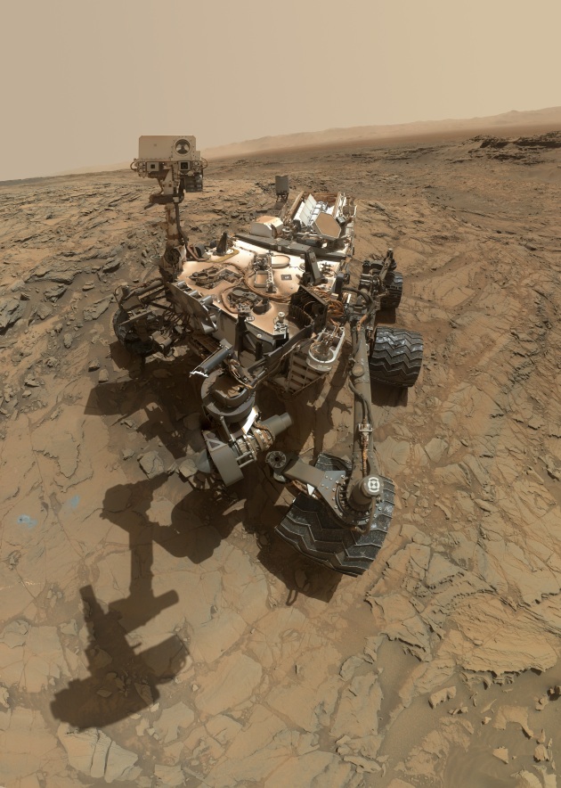
(Curiosity Self-Portrait at 'Big Sky' Drilling Site)[4]
.The image above, also seen at the top of the article, is a wonderful self-portrait taken by Curiosity in the ‘Big Sky’ area leading to Mount Sharp. The image was taken (the composite image, this image is a mosaic of several dozen images. The self-portrait was taken October 6th, 2015 by the Mars Hand Lens Imager (MAHLI) camera at the end of the rover’s robotic arm. The robotic arm is not pictured. This is the most recent self-portrait (in this style) taken by the rover.
.
 Knobbly Textured Sandstone on Mount Sharp, Mars
(Knobbly Textured Sandstone on Mount Sharp, Mars)[5]
.The image, above, shows patches of Martian sandstone visible in the lower-left and upper portions of the image, they have a knobbly texture due to the nodules that are apparently more resistant to erosion than the host rock. The image was taken with the Mast Cam on the rover, and taken on March 9th, 2016. This sandstone formation was sighted on the rover’s approach to the ‘Naukluft Plateau’. . The image is present with a color adjustment that approaches the white balance seen here on earth. This mosaic is comprised of six images taken with the Left Eye of the rover’s Mast Cam. The white balancing helps earthbound scientists to recognize materials and elements in the images provided. Now, My Dear Shoevians, when NASA/JPL provides multiple versions of a particular image, then I will share the Real Color’ and the “white Balanced’ versions.
.
 Curiosity's Arm Over 'Marimba' Target on Mount Sharp
(Curiosity's Arm Over 'Marimba' Target on Mount Sharp)[6]
.Our next image, above, was taken during the week preceding the fourth anniversary of the mission's dramatic sky-crane landing. This image shows Curiosity lowering the robotic arm directly over the target called ‘Marimba’ on the lower side of Mount Sharp. The image was taken by the Navigation Camera (NavCam) on August 2nd, 2016. (a mere 16 days ago, My Dear Shoevians!) The robotic arm was lowered over a patch of bedrock that was selected for the rover’s next drilling operation. Once the drilling is complete, the rock powder is collected and transferred to the onboard laboratory for analysis and observation. My Dear Readers, in past editions of ‘The Mars Report’ I have shared images of the drill device, holes drilled by the rover and image of bedrock and sandstone post drilling. Today, I am working to give you a wide range of images, in a seven image edition of ‘The Mars Report’.
.
 Full-Circle Panorama Beside 'Namib Dune' on Mars
(Full-Circle Panorama Beside 'Namib Dune' on Mars)[7]
.Now, My Dear Shoevians, this image just might be one of those images. Meaning, that you might have to click on the image and have it take you to a larger version of the image to get the full impact of the image I have shared. What we have here, My Dear Shoevians, is a Full Circle Panorama Self-Portrait of the Martian rover Curiosity! It is not often that NASA/JPL shares for our enjoyment and edification. However, when the do? I really like to share them, as they show a huge area of the Martian surface in a rare landscape format. Directly behind the rover, closest to Curiosity and on the left side of the image, is the downwind face of ‘Namib Dune’. . ‘Nambid Dune’ is part of the ‘Bagnold Dunes’. Further in the background, and in the center-right side of the image, is ‘Mount Sharp’. This image was taken December 18th, 2015. Yes, My Dear Shoevians, this image is a little out of chronologic order. I had hoped that I would get everything perfect in this ‘All New’ edition of ‘The Mars Report’… but, alas, I am still human and did make this minor mistake. L However, in my defense, I am sharing this image of a dune face… because the nest image is a close-up of a dune face… that, well, I thought was incredible! So, without further adieu… I give you… this!
.
 Mastcam Telephoto of a Martian Dune's Downwind Face
(Mastcam Telephoto of a Martian Dune's Downwind Face)[8]
.Well, My Dear Shoevians, it becomes clear. My reason for placing the previous image out of chronological order, that is, becomes clear with the image above. This is the ‘Nambid Dune’ up close via the telephoto lens of the MastCam (Mast Camera). Again, My Dear Shoevians, you just might want to click on this image, too. This telephoto image of the ‘Nambid Dune’ just really struck me, as I was researching this week, for images for this ‘All New’ edition of ‘The Mars Report’. If you click on the image (now this feature is not available at all my blog location, but it IS available at the primary location of ‘The Other Shoe’). The ‘Nambid Dune’ is a part of the ‘Bagnold Dunes’ field along the northwestern flank of Mount Sharp. . The image was taken December 21st, 2015 during the 1,200th Martian Day, or sol, of Curiosity’s work on Mars. The top of the dune face is about 13 to 17 feet in size. This image, again, uses ‘White Balancing’ so it appears in Earth-Like lighting conditions. Yes, it looks like it is black/white, but if you click or enlarge the image you can see spots of red rocks, in the lower right area of the image. Now, I know that this is an impressive image…. And I said that it “really struck me”… However, if you are a long term Shoevian, then you know that “I save the best image for last”!
.
 Full-Circle Vista from 'Naukluft Plateau' on Mars
(Full-Circle Vista from 'Naukluft Plateau' on Mars)[9]
. My Dear Shoevians, this is a MUST CLICK image! Of all the images that I have shared, in this edition of ‘The Mars Report’, this image is breathtaking! This image was taken mid-afternoon, on April 4th, 2016, as a part of a long-term campaign to document the context and details of the geology and landforms along Curiosity’s traverse since landing August 2012. The view combines dozens of images in a mosaic of a vista from ‘Naukluft Plateau’ on lower Mount Sharp. Here is some of the description, from the NASA/JPL web site. . “The foreground and middle distance show a geologic scene dominated by eroded remnants of a finely layered ancient sandstone deposit. Since landing, the rover traversed through terrains dominated by water-lain sedimentary rocks (mudstones and siltstones, and early on, conglomerates), some of which have contained minerals like clays that attest to the ancient presence of water. However, the rover crossed into very different geology while climbing onto the Naukluft Plateau. The sandstone here appears to be dominated by thick layers of windblown sand, suggesting that these deposits formed in a drier epoch. These rocks resemble the types of rocks that a dune field like the "Bagnold Dunes"[10] . The scene is presented with the ‘White Balancing’ color correction to approximate earth lighting conditions. This gives viewers a better understanding of the view, and scientists a better view of the different types of rocks and rack faces. The center of the image is a portion of the Gale Crater, with the upper Mount Sharp on the horizon at the right of the image. It was taken with the MastCam (Mast Camera) with the left and right eyes. . With that, My Dear Shoevians, we come to the end of this edition of ‘The Mars Report’. As always, My Dear Shoevians, IF you have enjoyed this article? PLEASE ‘Share’ and ‘Like’ the article via your preferred social media outlets. I hope that all of you enjoyed this article, it did take me several hours, over two days, to; prepare, write, edit and publish. It is a labor of love, because I love sharing these images and the hope that (someday) mankind will return to the stars!
.
Thank you!
.
Adieu!
.

Daniel Hanning- Writer, Research Staff, Editor and Publisher of The Other Shoe
© 2010 – 2016 Hanning Web Wurx and The Other Shoe
.
 Green Way Laboratory's flagship Product MastiClean!
_________________________________________________________________________________ [1] http://www.nasa.gov/image-feature/jpl/pia19920/curiosity-self-portrait-at-big-sky-drilling-site
[2] http://www.nasa.gov/mission_pages/msl/images/index.html
[3] http://www.nasa.gov/image-feature/jpl/pia20166/new-waypoint-science-team-newcomers-for-curiosity
[4] http://www.nasa.gov/image-feature/jpl/pia19920/curiosity-self-portrait-at-big-sky-drilling-site
[5] http://www.nasa.gov/image-feature/jpl/pia20322/knobbly-textured-sandstone-on-mount-sharp-mars
[6] http://www.nasa.gov/image-feature/jpl/pia20764/curiositys-arm-over-marimba-target-on-mount-sharp
[7] http://www.nasa.gov/image-feature/jpl/full-circle-panorama-beside-namib-dune-on-mars
[8] http://www.nasa.gov/image-feature/jpl/mastcam-telephoto-of-a-martian-dunes-downwind-face
[9] http://www.nasa.gov/image-feature/pia20332/full-circle-vista-from-naukluft-plateau-on-mars
[10] http://www.nasa.gov/image-feature/pia20332/full-circle-vista-from-naukluft-plateau-on-mars
.
No comments:
Post a Comment